
Beautiful Lakes & Mountains, Good Roads Make for an Easy Start
We left Dawson Creek early in the morning after buying some last-minute supplies the night before, knowing that towns would be few and far between the further we got up the highway. The first few hundred miles are in pretty good shape without a lot of challenging curves right up through Fort Nelson, BC. Speed limits there are mostly in the 100kph (62mph) range except when you’re going theough a town. After that the road starts to cross the rocky mountains, twisting it’s way along lakes and through the mountains for about 200 miles before straightening out around the Liard River as you get closer to Watson Lake, Yukon Territory. This stretch of road has limited services (fuel) available, adding to the challenge.
Using The Milepost – An Acquired Skill

An indispensable although at times frustrating tool for navigating the Alaska Highway is The Milepost. Chock full of information on travel in Alaska and western Canada, this annual publication takes a bit of time to get used to, but once you figure out how to track your progress through the book (It helps to have a navigator track this for you.) it’s invaluable as you work your way up the highway, letting you know where you can expect to find food, fuel, camping or lodging. It’s not perfect and there were a few places where services listed in it were closed or not available, but I still wouldn’t head up the highway without it. Oh, and while it includes e-book editions for your phone or computer, it’s a paper book, no internet or cell service required. Check it out at themilepost.com. We’ll have more on The Milepost including insights into how we used it in our upcoming posts.
Cinnamon Buns & Diesel Fuel at Tetsa River Lodge

One of the few places to get food or fuel as the highway crosses the Rockies is the Tetsa River Lodge & Campground is about 70 miles up the highway from Fort Nelson. They have diesel fuel and gasoline available at prices that while high compared to home are reasonable (after converting from Canadian Dollars and liters into US dollars and gallons) considering the remote location. We were happy to be able to fill up and not need to worry about fuel until we got to Watson Lake.
In addition to fueling up the RV, we also were able to pick up a couple of their award-winning cinnamon buns. Voted a Top 50 Iconic Dessert in North American by Food Network in 2019, they were absolutely delicious.

As we got closer to Tetsa River and began winding into the Canadian Rockies the scenery became more beautiful. Much of this part of the highway is in Stone Mountain Provincial Park, which offers hiking, boating, fishing and other outdoor activities in addition to drive in camping at Summit Lake, the highest point on the Alaska Highway at 4,250 feet above sea level.
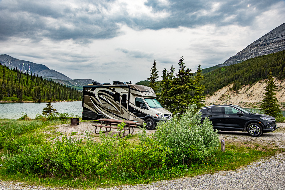
First Night on the Highway – Summit Lake Campground

We got to Summit Lake around 2:00 in the afternoon to find there were several great campsites available on the water, so we decided to stop for the day and enjoy the lake and surrounding mountains. It’s a gorgeous spot and a really nice campground for only $20 Canadian a night. There are several hiking trails in the area, but we weren’t able to enjoy them because not long after we got there the nice sunny day started to deteriorate as a storm started whipping up waves on the lake.
Summit Lake to Teslin Lake
From Summit Lake the highway continues through the Rockies, twisting and turning its way along the beautiful Muncho Lake in Muncho Lake Provincial Park. There are a couple of Provincial Park campgrounds along Muncho lake that are right on the water and look quite interesting, but we were looking to get further up the road and bypassed them.

After Muncho Lake the highway continues north toward the Yukon Territory, crossing the Liard River and becoming a bit flatter and less curvy as it comes out of the Rockies. Watson Lake, YT is the first real town we saw since Fort Nelson and it has a fairly comprehensive set of services, including a dump station (No potable water.) and a couple of gas stations and small groceries. We stopped in Watson Lake to dump our tanks and to repair the first casualty of the highway – our navigation system/multimedia system had come loose in the dash just past Summit Lake. Turns out the plastic side rails holding it in place had let go. A little glue should hold it until we get home and can make more permanent repairs. Not sure I’d really attribute this to the Alaska Highway. Looking at the design of the brackets it likely would have failed anyway, maybe at 20,000 miles instead of 10,000.
On to Teslin Lake Campground
Teslin is a small town with a couple of motels and gas stations along Teslin Lake in Yukon territory. The campground is about halfway up the lake and is on the water, although we weren’t able to find a waterfront site that would work for us. We did find an inland one for the night. One nice thing here was they had free firewood, all you need to do is split it. Kinda cool!
Check our blog page for more posts of our Alaska travels!
Leave a Reply